Using GPS Tracks
Many hikers are happy to simply follow way markers or maps while others are grateful for the detailed turn-by-turn directions in their Route Notes.
But these days GPS has become an important additional tool for navigation on the trails and many hikers are looking for GPS tracks of their routes that they can display and follow on their smartphone or GPS receiver. Those tracks can be a great aid to confirm that you are following the correct route. (For more information on GPS, what it is and how it works see further below)
Note: If you are using GPS for navigation please read the ‘Disclaimer & Navigating Safely’ notice below in order to make yourself aware of the potential issues that can arise when using GPS navigation.
Disclaimer & Navigating Safely
GPS is a great tool, but the most important means for navigation should be the way markers (where they exist), the directions in our route notes and the maps we provide you digitally or in printed form.
Although using GPS navigation may be your preferred option while on your tour, please be aware that there can be important info in relation to the trail / your tour within our route notes, therefore, be sure to always check our route notes in conjunction with the GPS tracks so you do not miss anything.
Whilst we take every care to ensure files are accurate at the time they have been created, they may not include short term diversions, trail closures or possible later changes to the route.
Additionally, we do not recommend that you use GPS tracks as the only tool for navigation. While it is tempting to use GPS tracks as your only guide for a hike, they might not reflect the latest changes to a route or include necessary local knowledge (and, unlike a map, they do not work if they run out of battery).
When using GPS to navigate on a hike, it is important to know that satellite reception can be disturbed. Fog, deep forests or mountain ranges can all mean that the determination of your position becomes less precise, fails or takes longer.
In addition, when using GPS, the power consumption of a GPS receiver or smartphone can be relatively high. It is advisable to always have spare batteries or a power bank with you and / or to keep an eye on the battery indicator as you hike.
Disclaimer: By using our GPS tracks, you acknowledge that walks are undertaken entirely at your own risk and that Hillwalk Tours can accept no responsibility or liability, nor gives any warranty, as to the accuracy of these files. Likewise, you acknowledge that Hillwalk Tours is the owner of the data and it is made available for use and to download only for your own personal use. It must not be made available to download from other websites.
HiiKER
To help you navigate our trails we have collaborated with the HiiKER GPS app, where all of our tours are now available for navigation.
Hiiker is a hiking and navigation app for your smartphone that offers excellent, easy to use navigation. The GPS tracks for all the main hikes, alternative routes, shortcuts and interesting detours for your tour are available in the app. In conjunction with the waymarkers and your Route Notes, our GPS tracks will make it easy to follow the trails and get the best experience out of your hiking holiday.
You can download the app here: HiiKER app | iOS and Android
Your HiiKER PRO+ Account
As part of your booking, we purchase a HiiKER PRO+ account for you that gives you access to the day by day walks, offline navigation and a selection of high-quality background maps from national and independent sources in the app that you can also print at home.
Login details for your HiiKER PRO+ Account are sent to you in an email, once your tour is paid in full.
Your Hillwalk Tours Account
You can access a direct link to all the HiiKER tracks needed for your tour in your Hillwalk Tours Account (myaccount.hillwalktours.com). In your Hillwalk Tours Account you can also find the details for your tour, your Walking Pack documents for download in digital format, and any updates or notifications we have sent you. Instructions on how to access your Hillwalk Tours account will have been sent to you previously.
Using HiiKER
Download and install the app (using the links above) and log in to you HiiKER PRO+ Account using the details sent to you by email.
(You may have to adjust some settings on your phone to get the best navigation experience. Check the HiiKER website for help: https://support.hiiker.app/)
For extensive information on how to use Hiiker, be sure to check out their ‘Getting Started’ section.
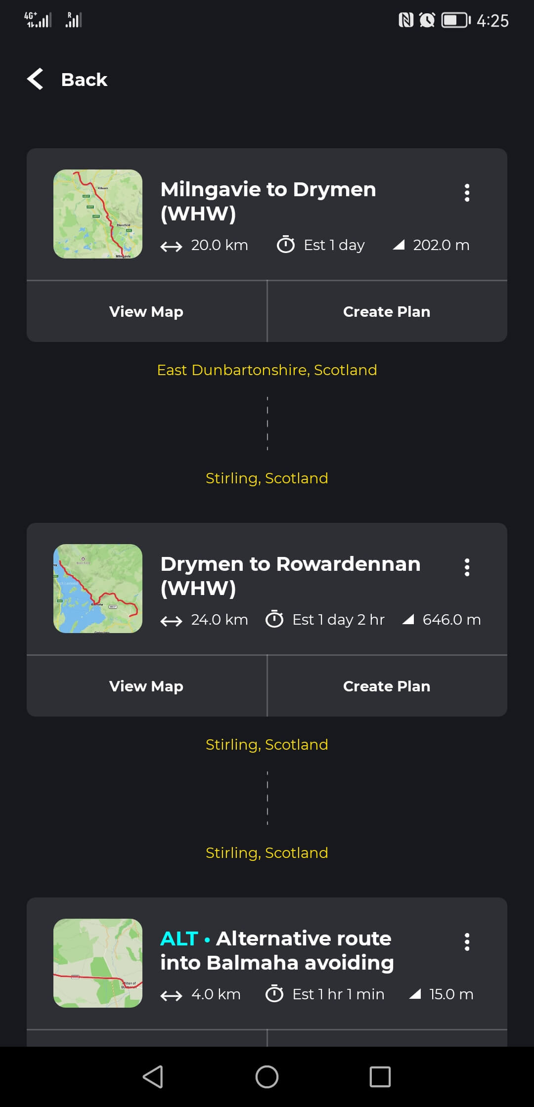
Trail Stages View
The HiiKER link for your tour, which you can find on your Hillwalk Tours Account, will open your tour automatically in the ‘Trail Stages’ view.
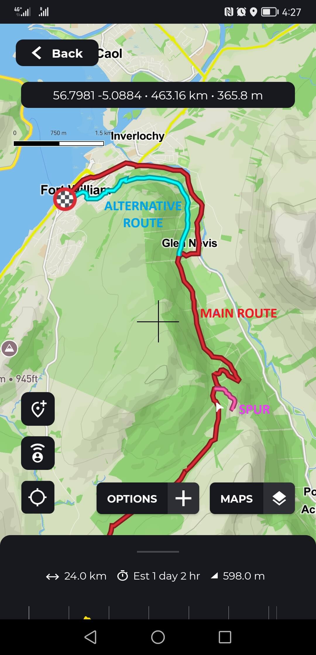
Each stage is named with that days’ hike and shows the main hiking route for a day of your tour.
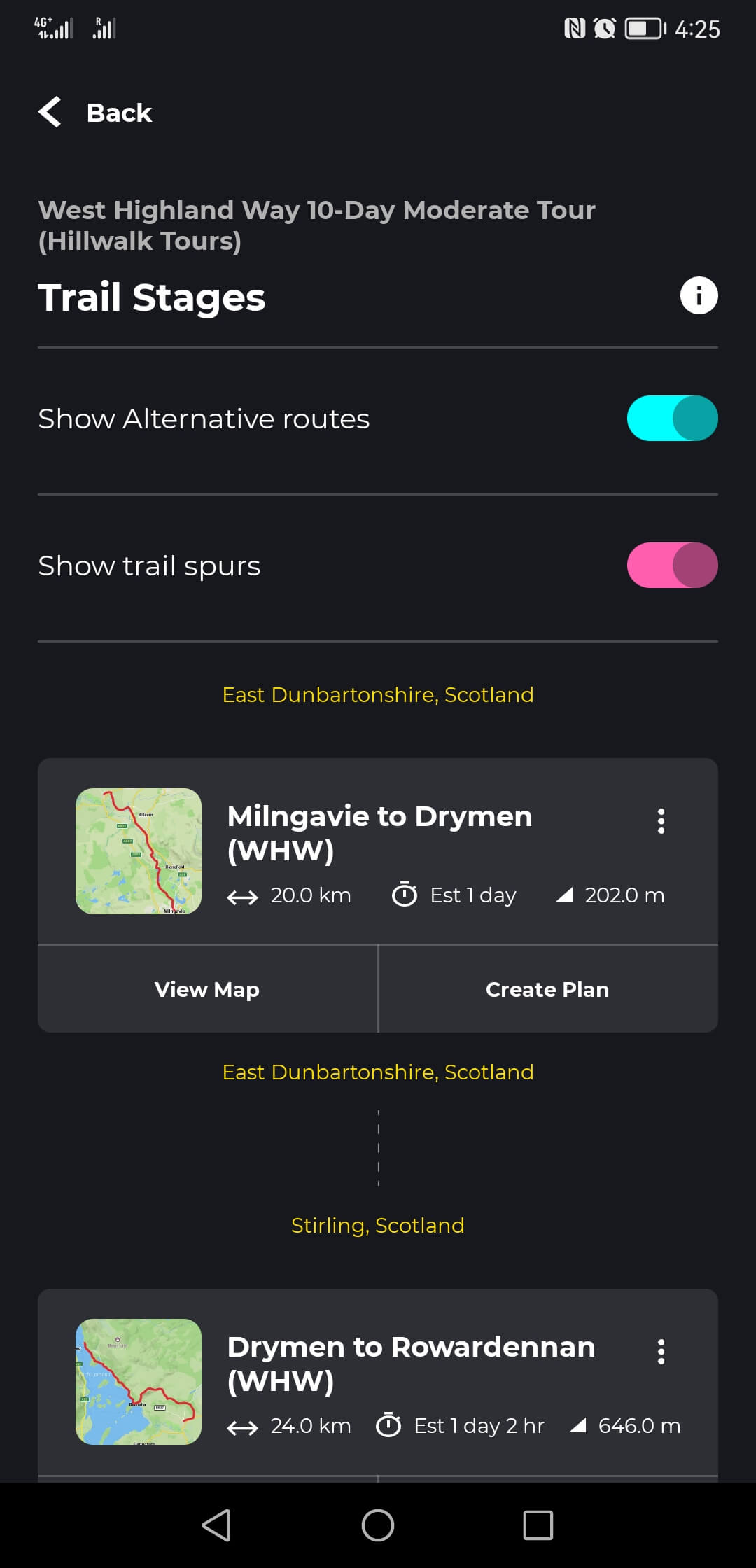
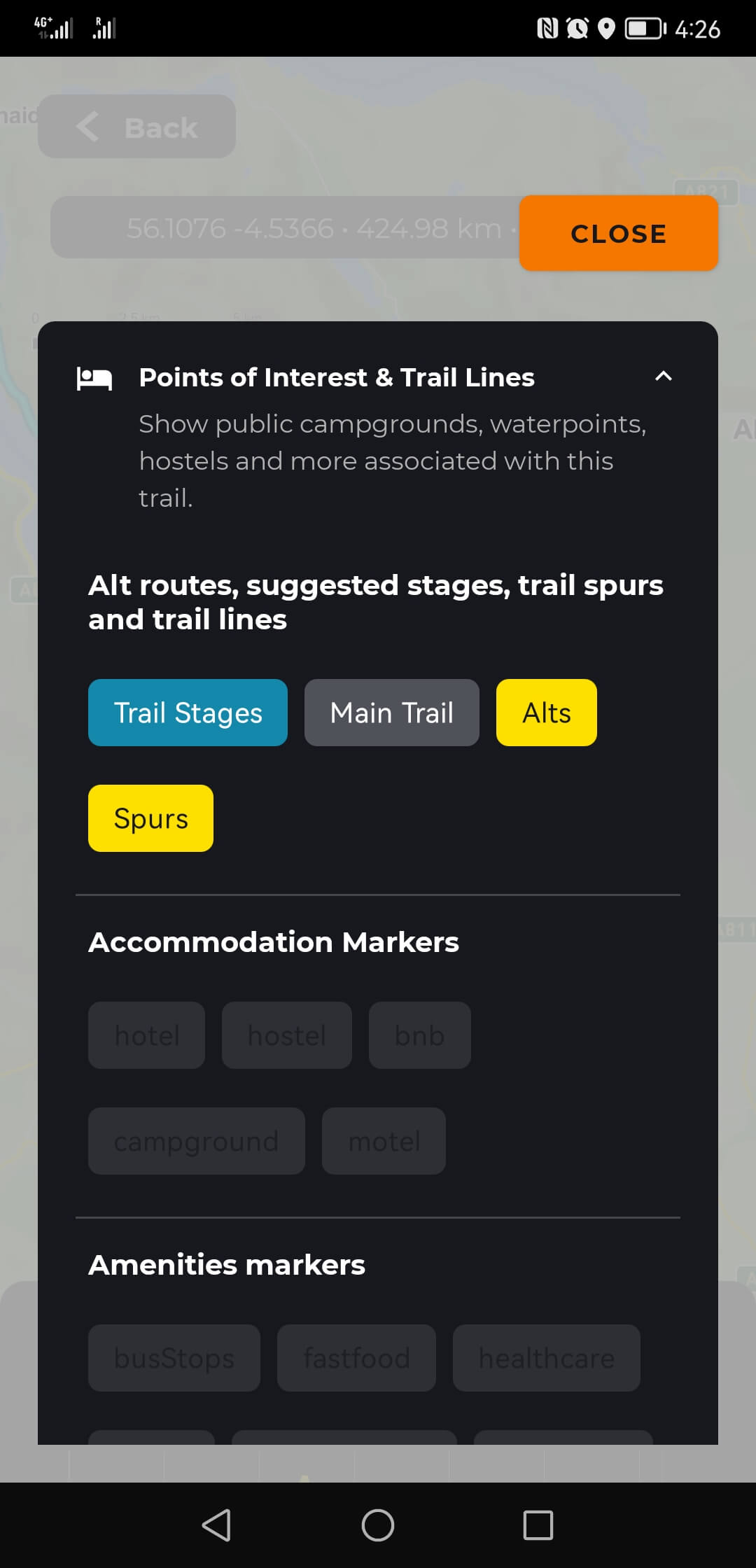
Alternative routes, shortcuts and detours are shown as ‘ALT’ or ‘SPUR’. In the map view, they can be turned off and on via the ‘OPTIONS’ button and ‘Points of Interest & Trail Lines’.
We encourage you to explore the maps and the trails for your tour using HiiKER before you start your trip to familiarise yourself with the app.
Download the Maps for your Tour
We recommend that you download the maps for your tour before your trip, so that they are available offline: Open the map for one of your hikes and select maps in the bottom right. Here you can select what map type to show and also download the maps for the entire tour for offline use.
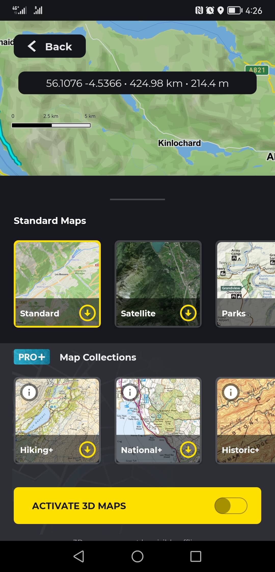
Alternatively, in the ‘Trail Stages’ view tap ‘Back’ and under ‘Start Navigation’ swipe left to show a button for ‘Download’. Tap this and select the download button (arrow down) for the map type you wish to use.
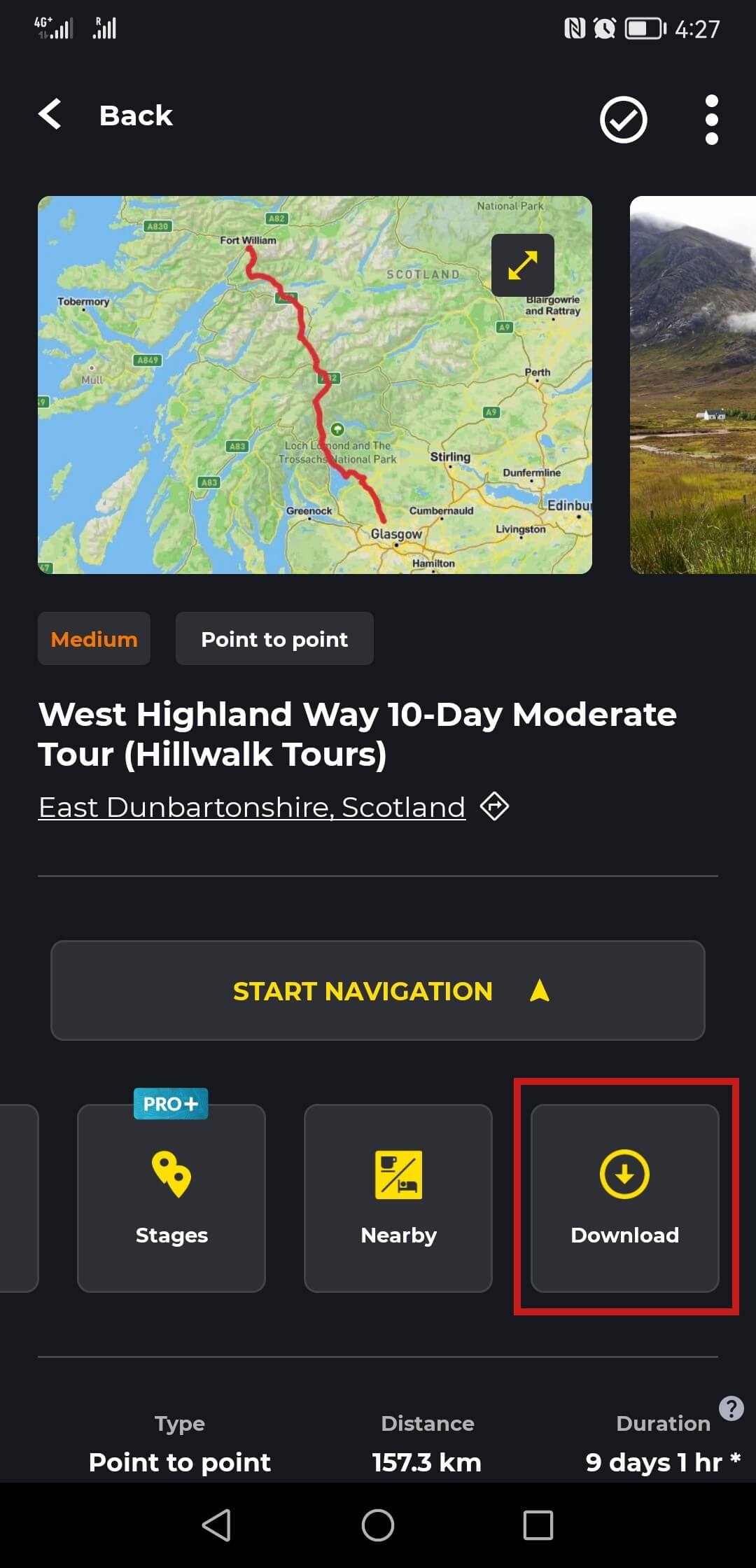
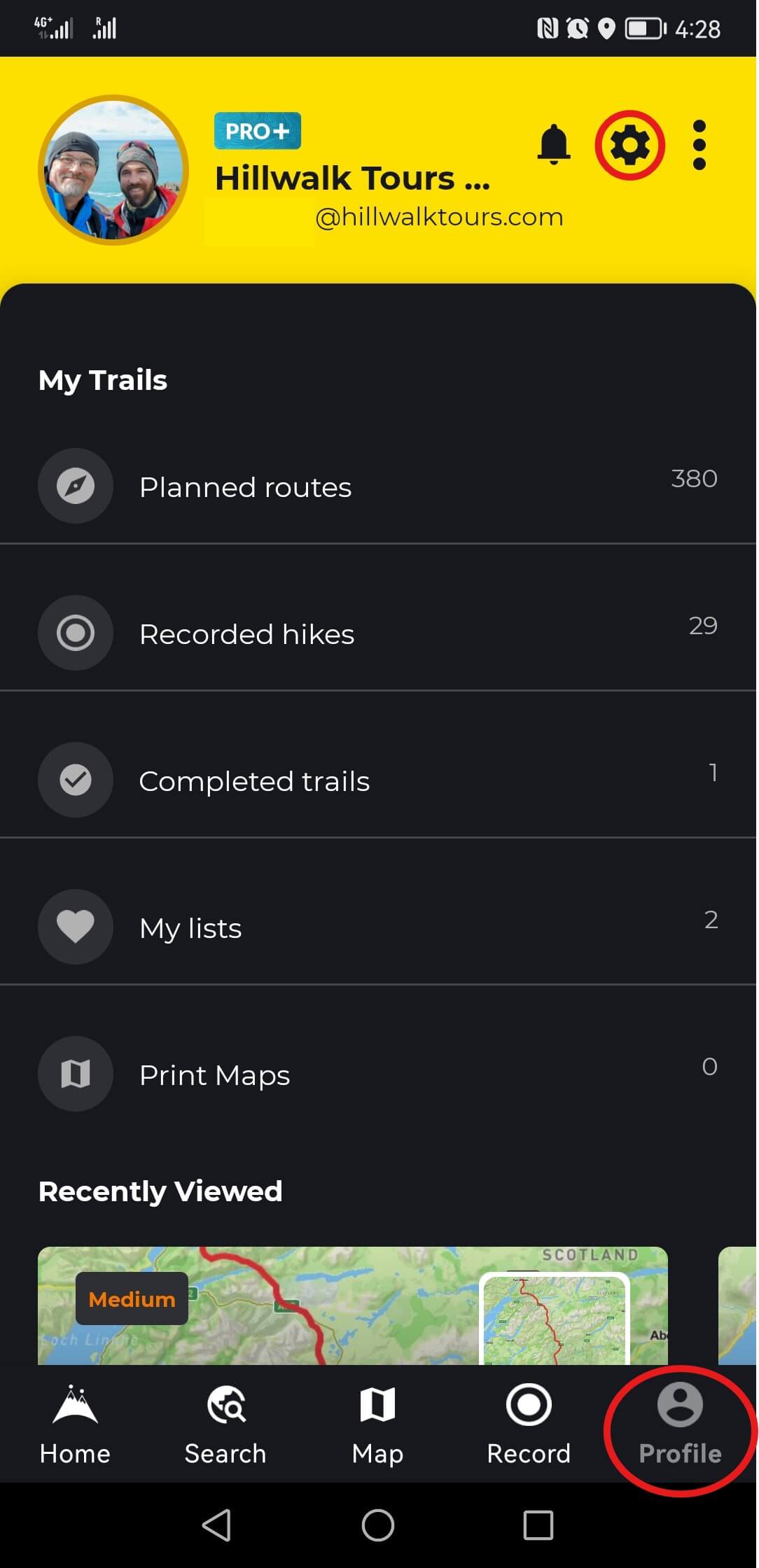
The tour will be available offline under ‘Recently Viewed’ under your Profile in the bottom right of the app.
Navigation
To start navigation, open that day’s hike.
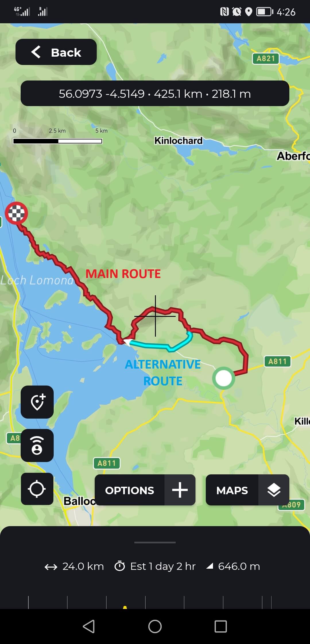
Remember, the main route is shown in red while alternative routes, shortcuts and detours are shown as ‘ALT’ (turquoise) or ‘SPUR’ (pink). They can be turned off and on via the ‘OPTIONS’ button and ‘Points of Interest & Trail Lines’.
Under ‘Maps’, select the available maps that best suit you (you may have downloaded these already for offline use)
When you are ready to follow the trail, tap the location button ( ) to show your location on the map and tap it again to enter ‘compass mode’, which is similar to the way car navigation shows the directions you are driving.
All you have to do now is start walking and have fun 
Daily Distances and Ascents
The daily distances and ascents (cumulative elevation gains) are automatically calculated in the app and might appear different from the values we have measured and calculated for your tours.
Hiking Times
In HiiKER, the hiking times are calculated based on the average hiking speed that is set in the app. To check what average speed is set in your app tap ‘back’ and go to ‘Profile’ in the bottom right of the screen. Tap the ‘gear/cog icon’ at the top to access ‘Settings’ and then select ‘Customize’.
Here you can change various settings, such as the units for distances, elevation or temperature, and specifically the ‘Hike Time Setting’ where you can select your average speed of walking or running under ‘Hike Time’.
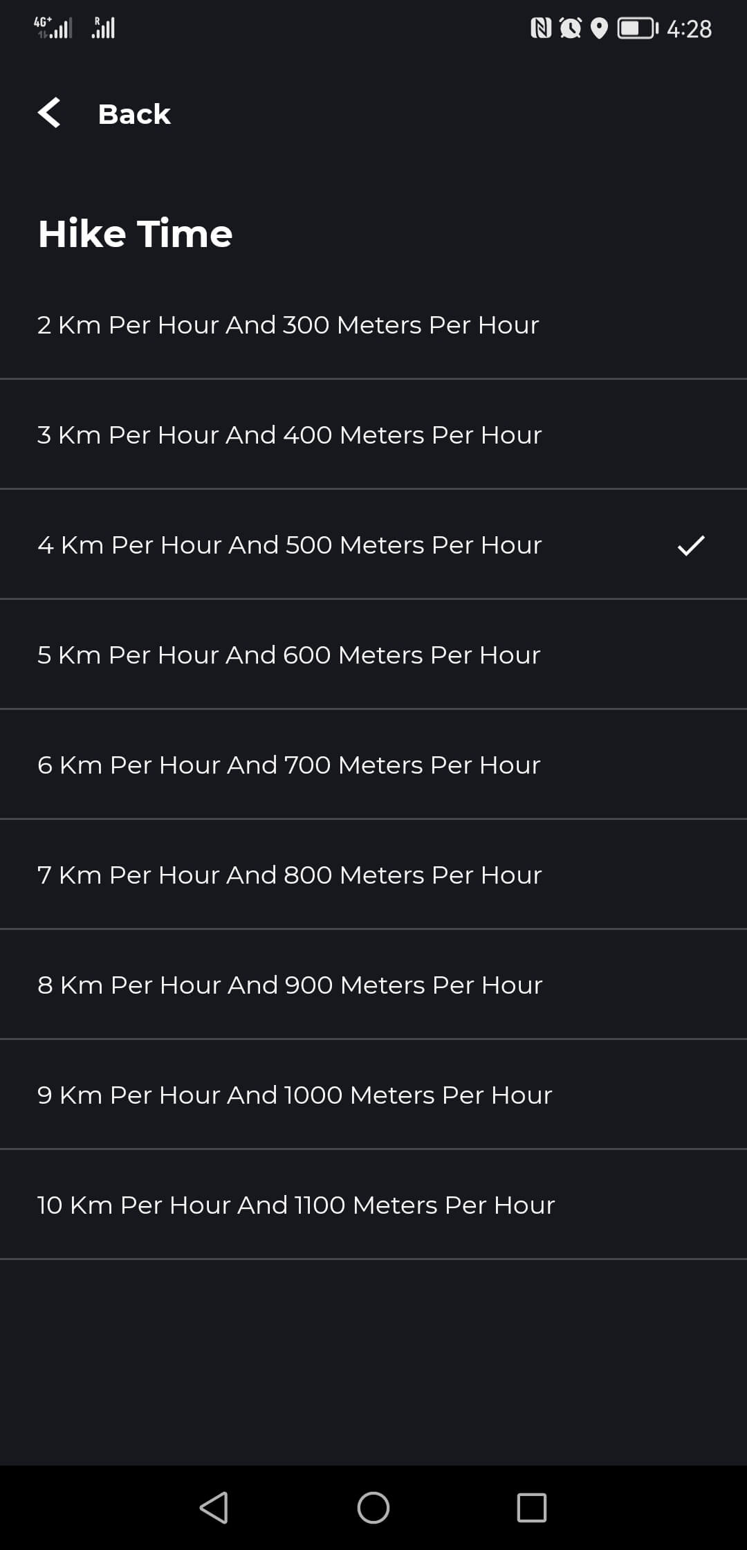
Our moderate tours are generally calculated for an average hiking speed of 4 km per hour, with a climbing speed of 500m per hour (in other words, climbing 500m in elevation is equal to 1 hour or 4km of flat distance).
For gentle tours we often use a slightly slower average speed of 3.5 km per hour and for challenging tours a slightly faster speed of 5 km per hour.
More Help
You can find a lot of helpful information and tutorials at support.hiiker.app to help you with the app and with navigation on the trail. But please keep in mind that we have invested in some development of HiiKER to make it work best with our tours. Because of that some parts of the app may look or work slightly different from what is shown on the support page. If you have difficulty logging into HiiKER or have forgot your password, please follow the ‘Forgot Password?’ process on the HiiKER login screen.
Other FAQ’s
What is GPS?
GPS stands for Global Positioning System and was developed by the US military in the 1970s. With the help of 24 satellites, this technology is used to determine locations around the world. A GPS device receives signals from the satellites and calculates its own position. In recent years, other nations have added their own satellite navigation systems and most modern GPS receivers can take advantage of more than one system.
Over the last two decades, the use of GPS (Global Positioning System) devices has become common to aid navigation on roads, the sea and in the hills, whilst over the last couple of years many Smartphones equipped with GPS technology have been used for the same purpose.
How does GPS work?
(Adapted from walkhighlands.co.uk)
Both stand-alone GPS devices, and smartphones with GPS technology, work by receiving signals from a series of satellites. The GPS receiver in your mobile device compares the very precise time signals it receives from the satellites with its internal clock. Knowing the location of the satellites, the speed the radio signal travels at (speed of light) and when the signals were sent and received, your device can calculate your distance from each satellite, and thereby determine your longitude, latitude and altitude.
What does GPS actually do?
(Adapted from walkhighlands.co.uk)
There are a range of GPS devices and smartphone apps that have widely different functionality. At the more basic end, the GPS device or app may give you your current coordinates or grid reference so you can then use this to help to navigate with your paper map. Many devices will let you pre-plot a route using mapping software on your PC (such as Memory Map etc.), or download a prepared route from elsewhere. The line of the pre-planned route is then often shown on the screen.
At the top of the range are GPS devices and smartphone apps that allow you to purchase high quality maps (for example Ordnance Survey maps 1:25 000 or 1:50 000) which are then stored so they can be shown on your device (overlaid with any pre-planned route), with your current position marked.
Do you need a mobile phone signal for GPS to work on smartphones?
(Adapted from walkhighlands.co.uk)
No. There is some confusion in that, if a mobile signal is available to them, Smartphones may use something called Assisted GPS to gain the approximate location from the phone signal. The mobile signal is then used to speed up the calculation of the position fix from the GPS satellites. However, the availability of a phone signal has no effect on the eventual accuracy of GPS readings once a device has fixed its position; the purpose of a mobile signal is simply to get a fix faster when the GPS functionality is switched on. There are some apps that do require an internet signal to show mapping and navigation, and so are not likely to work in remote areas. However, there are many navigational apps which now offer offline access to maps etc.
How accurate are GPS devices?
(Adapted from walkhighlands.co.uk)
The first generation of consumer GPS devices gave an accuracy of around 15m, and often had difficulties getting a position fix in narrow valleys or where there was forestry cover. More recent devices and smartphones tend to now use High Sensitivity GPS which is much more effective in forestry, and can be accurate to around 4m once the device has established a good fix with a number of satellites.
My smartphone/GPS watch/Fitbit/Pedometer has measured a different distance from the one stated in my Route Notes?
We carefully calculate distances and daily ascents, using our recorded hikes in conjunction with advanced GPS and GIS tools. If you measure your hikes and get different values from the ones stated in the Route Notes, it is likely caused by the inherent inaccuracy of pedometers and recreational GPS devices.
Recreational GPS devices are not precision tools and no GPS is 100% accurate. Most newer recreational GPS devices and GPS-enabled smartphones are typically accurate to within a 3 m (10 ft) radius under open sky. But if there are any obstructions to the sky, such as a dense forest canopy, heavy clouds, high canyon walls or tall downtown buildings, these can scatter the GPS signals or cause them to bounce and lead to extra error in the GPS positioning accuracy. This can sometimes lead to GPS accuracies 30m (100 ft), or sometimes even worse than 100m (300ft).
Since the GPS device calculates distances in intervals it may measure shorter or longer distances if the measured points are not 100% on the trail. These little errors can add up to larger discrepancies over longer distances. Imagine if every other GPS point taken is a few metres or feet off to the left or right of your actual position. That can add up to a lot of distance.
Add to this the fact that you are usually not walking in the ideal straight line for a route and might take little detours and the ideal distance given for a hike might be 10% or more off from what you measure with your smartphone.
Can I use other GPS Navigation Apps or Devices for Navigation?
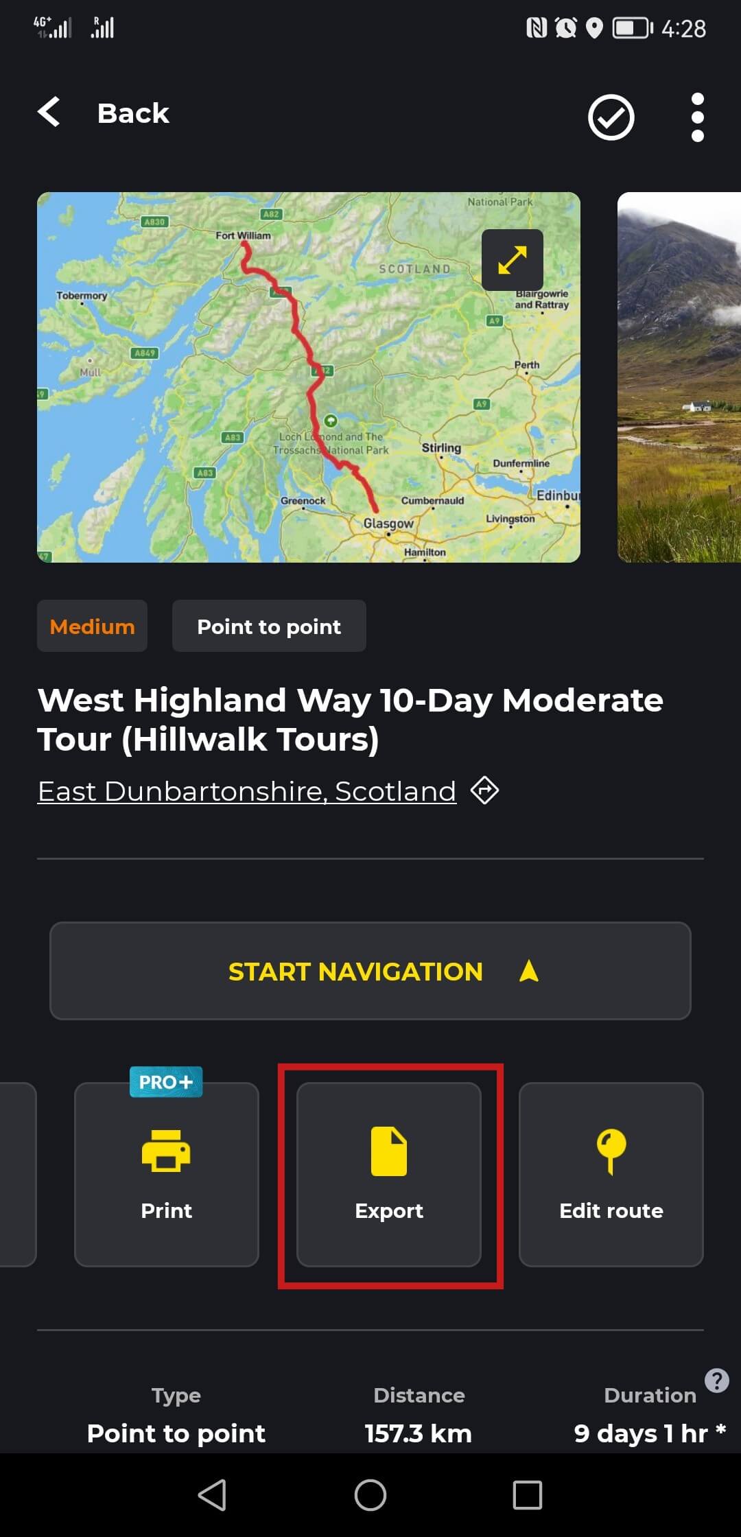
Should you wish to use our GPS data with other navigational apps or devices of your choice, you can do so by downloading the GPS data from HiiKER as a GPX file. To do so tap ‘Back’ in the ‘Trail Stages’ view and then swipe to the left on the tiles, where you see ‘Stages’ until you can see ‘Export’. Tap this to save the tour data as a single gpx file. To return to your ‘Trail Stages’ view tap on ‘Stages’.
Disclaimer: Please note that we can’t guarantee that the tracks will load correctly on other applications & devices as this is often determined by how an application / device reads the file. For example, most problems with GPX file incompatibility are due to various software providers adding additional information that is not compatible with all devices and programs that can use GPX files i.e. other devices / programs cannot open a GPX file where there is additional information it doesn’t know how to read.
Google Maps for Navigation?
Currently, we do not advise using Google Maps for off-road navigation. While Google Maps has improved in the last number of years for off-road hiking use, we cannot recommend it yet for navigation on our trails.
For example, Google Maps may occasionally not show you existing paths or tracks that we suggest for navigation. Google Maps just haven’t added those routes to their maps yet. Therefore, it is best to choose a mapping application that provides access to more detailed maps which have been designed for off-road hiking.
What other things should I consider when using GPS?
Before using GPS to navigate on a hike, it is important to know that satellite reception can be disturbed. Fog, deep forests or mountain ranges can all mean that the determination of your position becomes less precise, fails or takes longer.
Please also note that when using GPS, the power consumption of a GPS receiver or smartphone can be relatively high. It is advisable to always have spare batteries or a power bank with you and / or to keep an eye on the battery indicator as you hike.

